News
Ana Swanson
May 02, 2016
We don’t often question the typical world map that hangs on the walls of classrooms — a patchwork of yellow, pink and green that separates the world into more than 200 nations.
But Parag Khanna, a global strategist, says that this map is, essentially, obsolete.
Khanna is the author of the new book “Connectography: Mapping the Future of Global Civilization,” in which he argues that the arc of global history is undeniably bending toward integration. Instead of the boundaries that separate sovereign nations, the lines that we should put on our maps are the high-speed railways, broadband cables and shipping routes that connect us, he says. And instead of focusing on nation-states, we should focus on the dozens of mega-cities that house most of the world’s people and economic growth.
I spoke with Khanna about several of the incredible maps from his book, which he uses to illustrate some proposals for our future world that might, at first glance, seem pretty far out — like dividing the United States into seven economic mega-regions or politically integrating North America. But with the world rapidly changing and urbanising, these proposals might be the best way to confront a radically different future.
This interview has been edited for length and clarity.
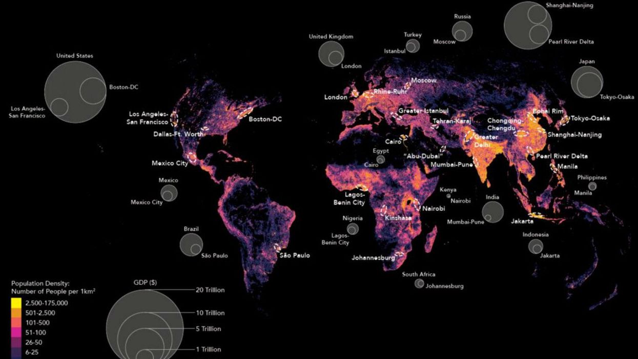
One of the most impressive maps in your book is the map of the world’s mega-cities. You say that by 2030, more than 70 percent of people will live in cities, and that these cities matter a lot more than the countries that they’re in. What does this map tell us?
This is the most accurate map that’s ever been made of where people are and the economic value of what they do. Our team took the entire world’s population and plotted it by density, and they superimposed the largest urban archipelagos, the mega-cities, with those ovals to show the value of those cities vis-à-vis the national economy.
The map tells us that the world economy is much more structured according to the gravity of these 40 or 50 megacities than the world’s 200 sovereign nations. In almost all countries, cities have all the economic mass and most of the population, and people are moving to cities by the hundreds of millions.
The example of Johannesburg and Pretoria, the capital cluster of South Africa, is revealing. It represents something like 35 to 40 per cent of the country’s gross domestic product, and South Africa is a very large country, with more than 50 million people. So much of the population is there, and the country’s connectivity depends on that city, because that’s where all the multinational corporations are headquartered. It’s the same logic in Lagos — there is practically no Nigeria without Lagos. It applies to Sao Paulo in Brazil, Jakarta in Indonesia, Moscow in Russia, Istanbul in Turkey, and every single dot and oval you see on the map.
The good news for America is we have so many major cities that we have a distributed economy. Other countries are not so lucky. Russia is bigger than America, but it has one city that drives the whole country.
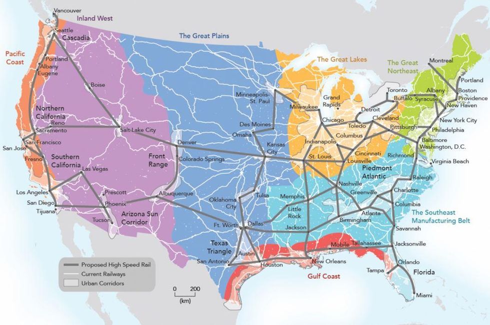
The map from your book that’s probably received the most attention is the United States broken down into seven economic mega-regions, all of which are driven by urban centres. You say that a high-speed railway could connect these cities, creating a “United City-States of America.” Why do you think we need to reorganise this way?
These seven colourful patches are the natural topography and economic geography of the United States. It separates the US into areas that focus on farming, automobile manufacturing, technology, finance, tourism, national parks, etc. Each of those regions has an urban anchor that serves as a financial and business centre, a population centre and a transportation hub. That’s what those white patches are. Then we need the black lines, which are the high-speed rail networks and freight railways connecting these regions to each other.
We need to rethink the political and functional geography in the United States. It’s kind of ridiculous that we use 200-year-old logic to govern the economics and functional reality of day-to-day life in our country. Of course, we do it for votes — having 50 states is great if you’re running around in a primary. But it doesn’t help you make America a more viable or competitive economy.
All of the feedback I’ve gotten about this map has demonstrated that there is so much frustration with the layers and layers of bureaucracy, for the police and the education system and the government, in large and small states. All we do is duplicate bureaucracy, when we should be regionalising our coordination of economic affairs. Of course, there are a bunch of birthers who have been like, ‘Who the hell is this technocrat guy who doesn’t live in America, is he even American, does he have the right to do this?’ But I do see the enormous groundswell in support of these ideas.
But this reorganisation is so dramatic – could we even do this?
We have the ability to do this. I hate to make the punch line something that’s so banal, which is “It’s all Congress's’ fault,” but it’s all Congress’s fault. All Congress has to do is to make sure that instead of district- and state-level pork barrel project spending, projects have some kind of cross-border dimensions, so that American citizens, whatever state they live in, can be better connected to the big cities. And if you do that, the laws of economics will take over, and people will more freely engage in commerce.
A map like this would enable Americans to flow more freely around the country. That is the difference between America and the European Union. We are a United States; you don’t need to go through a border check to cross state lines. And yet we’re not taking advantage of that freedom of mobility across this incredible geography.
Right now, the political conversation in the United States and elsewhere seems to be more focused on the rejection of free trade and of immigrants, and uncertainties about the future of transnational projects like Eurozone. How does that jibe with your overall theory that the world is becoming far more connected and integrated?
We have to distinguish between what some people in politics are saying, and what the reality is. We can’t treat the fact that Donald Trump has an idea about a wall, or that Bernie Sanders is against certain trade agreements, as reality. Almost every syllable that you hear in the populist discourse is wrong.
In the real world right now, we have more trade, more immigration, more cross-border investment than at any point in history. We are massively expanding global flows in goods, services, finance, people, data. You name it, it’s going up.
If you look at the United States and Mexico, most of the world views Mexico as a very hot emerging market. That’s true of American companies: The American financial industry is buying into pipelines and power grids, and American automobile manufacturers are relocating. And they’re doing so not just because of cheap labour, but because Mexico has preferential trade agreements with other Latin American countries, which means if you manufacture there you can generate more sales in a fast-growing region.
When an American car manufacturer relocates some production to Mexico, yes, some jobs are moved. However, the car manufacturer is able to stay solvent, because it saves costs and builds more cars, and built into the agreement is a requirement that North American suppliers are preferred for that automobile plant. The number of people employed in auto part supply making in the US — high-tech air bag makers, anti-lock braking sensor developers, and reflective lights developers — is also in the hundreds of thousands, and those companies benefit. Those are the sort of new high-end manufacturing jobs that ultimately matter if you want American workers to move up the value chain within advanced manufacturing. They can be expensive suppliers to the lower-wage car manufacturers in Mexico.
Our inability to do that is our fault. You hear Bernie Sanders and Donald Trump scapegoating globalisation — it’s the dumbest thing I’ve ever heard. America has been the creator and driver of globalisation over the last 25 years. Yes, it is now a more level playing field, and we are not always the winners, but that is the fault of politics and bad policy. In 2004, a pillar of John Edwards's presidential campaign was worker retraining programmes for new industries. Twelve years later, where is that programme? Just because we didn’t create it, doesn’t mean it doesn’t exist. The Germans did it, the Swiss did it, the Koreans do it. Other countries don’t blame globalisation, they manage it, they take advantage of it. I think we failed to do that, and that’s what explains Trump and Sanders.
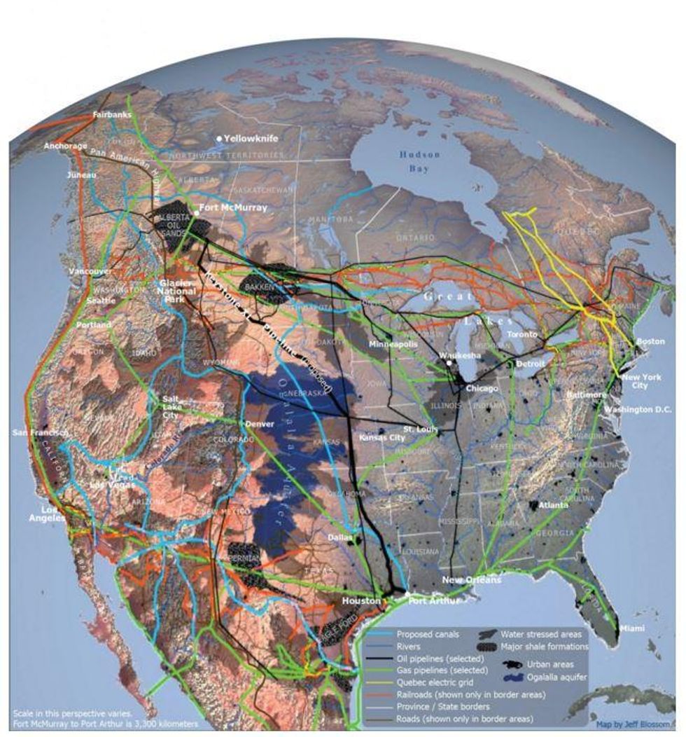
Speaking of these connections between the U.S. and Mexico, one of your maps shows how North America is increasingly integrated. I know you mention in your book that the US-Mexico border is the most frequently traversed border in the world, and the US-Canada border is also extremely busy. Why is North America so integrated?
One of the titles I’ve given the map is ‘Think geology, not nationality.’ America is now suddenly the largest oil producer in the world. The American energy revolution is the most significant geopolitical event since the end of the Cold War, and it’s a major shift in the world’s tug of war.
Ten years ago, we were all talking about how the United States and China were going to fight resource wars for Middle Eastern oil and minerals in Africa. Now, thanks to this incredible seismic revolution, we’re selling oil to China instead.
The reason this relates to North America is because, if you think about strategy in the geological terms, you realize that if the US, Canada and Mexico unite their energy, water, agriculture and labour resources, you create a continental empire that is more powerful than America is. I’ve not even mentioned the Arctic, which of course Canada controls half of, which is becoming a very strategic geography as the Arctic ice melts. Canada is going to potentially be the world’s largest food producer in 20-25 years as a result of climate change.
And then there’s water. The southwestern United States is now in a perennial drought, and yet at the same time, perversely, is the site of the fastest growing population in the United States. So hydrological engineering may need to take place between Canada and the United States.
The way you build this continental superpower is connecting North America together. The more pathways and routes you have for supply to meet demand, the more resilient your system. So that’s why that map should be taken extraordinarily seriously. It is not just a pretty picture, it is literally what American grand strategy should be in the 21st century.
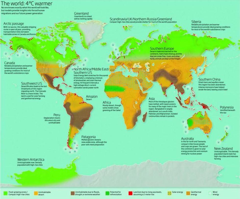
You mentioned the issue of climate change and food production. One of the most fascinating maps in the book shows how global considerations might change if the world becomes four degrees Celsius warmer. Much of the United States becomes uninhabitable desert, while cities and food-growing zones shift to Canada.
This is a map by the New Scientist, a very respected British journal. They made this forecast of where global food production would be relocated to if the world rises four degrees Celsius above the 1990 baseline, which of course the Intergovernmental Panel on Climate Change uses. Where today the world’s largest food producers are the United States, Brazil, China, India, Australia and so forth, it could be that 30 years from now or less, the world’s largest food producers are Canada and Russia.
This is ironic for a host of brutal reasons. First, these are two of the most sparsely populated countries in the world. Do you know what the world population is north of 66 degrees latitude, near the Arctic Circle? It’s less than the population of Manhattan. For this book, I went up to the northernmost tippy-top of Norway to look at the Arctic supply chain. Not only are temperatures rising there, but populations are growing, new towns are developing, ports and shipping industries are thriving, in these super cold places. And I met these old people who actually remember when things were a lot colder, because it’s not as cold as it used to be, though for me it was still damn cold.
The year 2050 or 2100 seems like light-years away. But if we agree that climate change is not getting reversed or slowed down by our current efforts, you have to take seriously the idea that the world’s existing political boundaries and restricting the movement of people don’t make a lot of sense. Canada isn’t going to be just for the Canadians, and what we today call Russia isn’t just going to be for the rapidly diminishing Russian population.
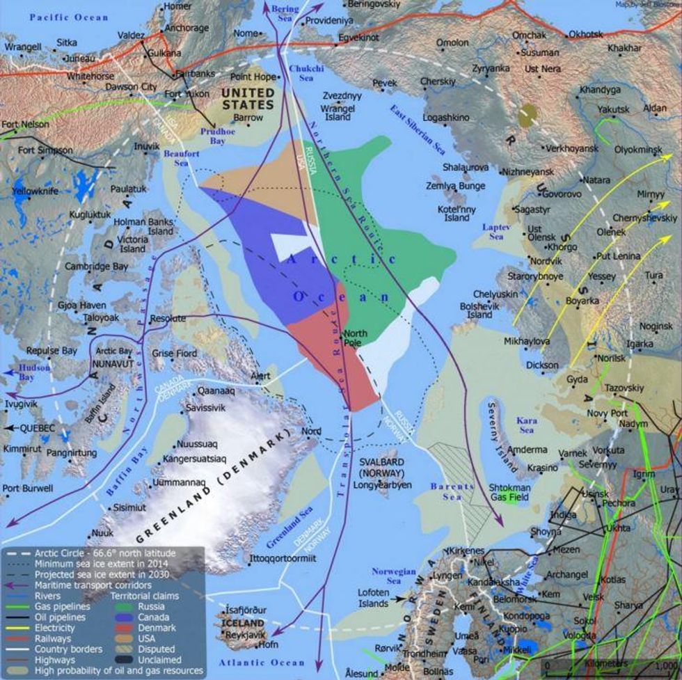
You also have a map that looks at “The New Arctic Geography.” This isn’t a view of the world that a lot of people are used to looking at, but something they will need to get more used to over the next decades. What is the importance of this region and these shipping lanes?
They play a very significant role in geopolitics. The world has four significant maritime choke points, three of which are geopolitically sensitive — the Suez Canal, the Strait of Hormuz and the Strait of Malacca. We have feared for 100 years that there could be an act of terrorism or war that would block one of these choke points and disrupt global trade and energy flows.
But Arctic shipping is a faster and better system. Tragic as climate change is, it opens up these new passageways to Europe, to North America, into the Hudson Bay. So the way into the heart of North America may eventually be these Arctic shipping routes.
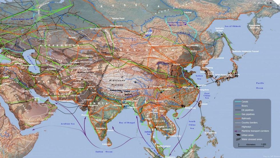
Let me ask you about your map of Eurasia’s “new Silk Roads,” which shows some of the projects being built by the Chinese-led Asian Infrastructure Investment Bank. You also describe competitive connectivity as the next arms race. Compared with the United States, is China really winning the battle for connectivity?
There is no final winner in this competitive connectivity, and it’s not zero sum. We’re all benefiting in some way from this build-out of infrastructure that has been neglected for decades.
This map of the new Silk Roads shows the railways, pipelines and so forth that are going to be built by the Asian Infrastructure Investment Bank and other organisations across much of Eurasia. Right now, Europe’s trade with China is almost the same as Europe’s trade with America. Just imagine how big that economic bloc will be when all of those trade corridors are complete and you have seamless transportation between Europe and Asia.
America definitely took the wrong approach, which was to try to block the creation of the Asian Infrastructure Investment Bank. Meanwhile our closest allies — the UK, Germany, European countries — signed on as the bank’s charter members. The Obama administration basically pretended like this was a zero-sum tug of war over allies, but they didn’t realise that America’s military alliance system is not the only way of understanding global public goods. We think of security as the most paramount global public good, and America is the leading provider of that good. But what China has shown is that infrastructure is an equally important public good. Hundreds of countries desperately need and want infrastructure, and China is the world’s leading provider of that.
In the book, I have so many examples of why we should let China go ahead and build all of these things, but we should be competing for the lucrative value-added deals. We don’t have millions of American construction workers to export to Africa. But when those countries finally start to use their connectivity to build factories that are making useful things, we should be the ones financing the deals and selling the technologies. China builds up the world, and we get to benefit from the growth of those markets.
Washington Post ©
More: These beautiful maps will change your perspective of the world's coasts
More: The beautiful maps that show all the roads leading to Rome
Top 100
The Conversation (0)
